Custom maps are one of the best ways to imagine the whereabouts and chronology of ancestors’ activities:


10 Friday Jul 2020
Posted in Abbeville, Edward Maddox, Maps
Custom maps are one of the best ways to imagine the whereabouts and chronology of ancestors’ activities:
17 Wednesday May 2017
Posted in Developing stories, Edward Maddox, Maps
Tags
We’ve established that our 9th great grandfather lived in southern Shropshire, England, before emigrating to Maryland in the mid-1600s. As we begin to dig into local Shropshire records in search of more data and stories, it’s useful to place the family in the historical and etymological context of Shropshire and their presumed earlier home of Wales.
Madog/Madoc is the original spelling of our name, as used in Wales as a forename by ethnically/culturally Welsh ancestors at least as long ago as the 6th century. Saint Madoc established a monastery in the 6th century at the eponymous Llanmadoc, on the Gower Peninsula, but that doesn’t mean he was the first Madog/Madoc in the area and it doesn’t give us a clue to the earlier origins of the name. One writer has made a speculative claim that Saint Madoc’s DNA is similar to DNA found among the Gaulish Medulli people, including a Medulli group that lived in Medoc, France.
The Madog/Madoc lines in Wales are famous for their short-lived kingdoms and their rebellions against Norman and English invaders. Kings bearing the Madog name had a part in the establishment of the Powys kingdom after the Romans left Wales in the 5th century, and kept the Powys kingdom going for centuries. Our known 17th-century ancestors might have descended from Powys’s Mathrafal dynasty, which included the 12th-century founders of the Powys Fadog kingdom (Fadog means Madog) and the Powys Wenwynwyn kingdom some decades later. These kingdoms once held the majority of Wales and parts of Shropshire. The Powys Fadog kingdom was politically centered on Dinas Bran and spiritually centered on Valle Crucis. The Powys Wenwynwyn kingdom included Munslow, Shropshire, where our Edward Maddox lived in the 17th century. Perhaps the Powys Wenwynwyns deposited Edward’s grandfathers there.

Castle Powis in Welshpool, Wales, was originally owned by the Powys Wenwynwyn line. It is now the property of the Earl of Powys. The castle is open to the public and includes art and objects stretching into the 15th century. We took the above courtyard photo during a tour in 2017.
The Powys Fadog kingdom fought with the Gwynedd kingdom to the north, which included numerous prominent Madog/Madoc relations. The Gwynedd kingdom would defeat the Powys Fadog kingdom in the 12th century. The most famous Madog/Madoc to come from the Gwynedd line was Madoc ab Owain Gwynned, who legendarily sailed to the American continent in the 1100s, and whose descendants would purportedly be found living among Native Americans in the 1600s and speaking Welsh.
When American Maddox researchers claim ancestry in Wales via 17th-century Maryland and Virginia colonists, it’s usually a claim to the Maddoxes of the Powys Wenwynwyn kingdom, whether the researchers know it or not. This claim was propagated by Fredonia Maddox Webster in the first four pages of her 1957 book, The Maddox Family of Maryland. She relayed a romantic British description of the Madogs of Llanfrynach (a few miles southeast of Brecon), whose ancestors rebelled against the Crown before being reduced to minor local nobles. Webster’s four-page genealogy of the Madogs of Llanfynach begins with King Arthur and ends with John Maddox, progenitor of Maryland colonist Samuel Maddox.
Many hopeful family historians have claimed that their Maddox line includes a Thomas Maddox, who settled near Jamestown, Virginia, in 1620 and died by 1623 (possibly due to injuries after the Indian Massacre of 1622). They claim that this Thomas is identifiable with “Thomas Lord Scethrog,” and again they refer to Webster’s book, even though Webster writes that Thomas died in 1620. Webster claims that Thomas Lord Scethrog was the father of John Madog, who was the father of Maryland colonist Samuel Maddox. One researcher has found a 1607 gravestone for a “Gwladis, married Thomas Maddock, Lord of Scethrock” in Saint Meugan’s Church in Llansantfraed, providing perfect evidence for a geographic location… if only the genealogical link to the Maddox colonists could be proven. But so far it has been impossible to actually document known Colonial ancestors into the royal Madog/Madoc lineage in Llanfrynach.
While hopeful Maddox family historians may claim links to Fredonia Webster Maddox’s 16th-century Madogs of Llanfrynach, our own Maddox ancestors were living 60 miles to the northeast in Munslow, Shropshire, at that time. Our Maddoxes were geographically closer to the extraordinarily beautiful Powis Castle, where the last of the Powys Wenwynwyn heirs lived in the late 13th century. But the illegitimate son of the last Powys Wenwynwyn prince sold the castle to the Herbert family soon thereafter. The Madogs of Powys Wenwynwyn were dispersed throughout the modern area of Powys.

The kingdom of Powys Wenwynwyn included western Shropshire, where Edward Maddox lived in the mid-1600s. Credit: Wikipedia.
The name Madog did not originally serve as a static surname. It was a forename. Parents could name their sons Madog for many reasons, and the use of the name didn’t necessarily mean a blood relationship to any of the Madogs that came before. For this reason, not every Madog in Wales should be considered a relative. One researcher provides a deeper explanation here and another expresses frustration here.
For over a millennium, the ethnically/culturally Welsh used the Madog forename as a patronymic, meaning that a man would identify himself with his father’s name (or rarely his mother’s name). For example, Madog ap Dafydd meant Madog son of Dafydd. A woman would use matronymics, placing the term ferch (daughter of) before her mother’s name. This was intended to establish genealogy for legal proceedings, but records and genealogies among the ancient Maddoxes are few and questionable.
While Welsh ancestors called themselves Madog/Madoc, ethnically/culturally English ancestors just to the east simultaneously spelled their name Madocke/Maddocke, based on a study of thousands of 16th-century records.
The use of patronymics generally ended in 1536, when Henry VIII passed the Act of Union, which put an end to the tradition in favor of Anglicized surnames. Some families then incorporated the ap at the front of their surnames. For example, the Rice surname became Price. Other families added a possessive s to the end of their surname. For example, Jone became Jones. In England, Madog/Maddock became Maddocks/Maddox. But the Welsh continued to use Madog/Madoc.
The transition to Anglicized surnames in the mid-16th century can help us establish geography and distinguish between families. Our known ancestor Edward Maddox and his children used English spellings as early as the 1640s in Munslow Parish baptismal, marriage and burial records, implying English cultural/ethnic identity. This could also imply an eastward aspect: they probably had been doing business with the English, whose centers of commerce were to the east toward London.
Among the intriguing records we’ve already found in the Shropshire Archives is the 1630/1 will of John Everall of Wentnor, Shropshire, referring to his son Edward Maddox and his grandson Edward Maddox. The dates match our Edward Maddox’s chronology, location, and son’s name in Shropshire. But why a man with the surname Everall would have a son and grandson with the surname Maddox is… confusing. But if we reverse-engineer Everall’s name into his original patronymic (for example, the name Evans was originally ap Ieuan), we see that he might have been called ap Iarll before surnames were fixed. Ap Iarll translates to “son of Earl.” Perhaps – just speculation – he was derived from the Powys Wenwynwyn royal line, and had a complex series of wives and children, as many of the royals did. Or maybe the story is much more basic. Lots more work to do.
21 Friday Apr 2017
Posted in Developing stories, Edward Maddox, Maps, Uncategorized
Tags


We’ve been trying to understand our Edward Maddox‘s (d. 1694) origins in Shropshire, England, and add any more evidence to our assessment of his migration to the American Colonies. Most evidence of such early migration is oblique, so maybe it shouldn’t be surprising to find hints of Edward’s origins in obscure write-ups about the 17th-century English cloth trade…
It turns out that the town of Shrewsbury, in Edward’s County of Shropshire, was the center of trade (export) for woolens and the headquarters of the Drapers Guild. Edward lived just south of Shrewsbury in the town of Munslow, placing him ideally for involvement in the cloth trade. Perhaps he was warehousing locally grown wool. Other towns in the area were used as markets or warehouses.
One author explains that “The ‘proud Salopians’ of Shrewsbury, as their rivals termed them, achieved the high-water mark of their prosperity in the century before the [1642-51] Civil War: the town’s population rose from 3,000 to 7,000, the urban area was largely rebuilt, and the borough evolved from a county seat into the economic and social focus of an area stretching from the Wrekin to Cardigan Bay. Shrewsbury’s urban growth mirrored developments at neighbouring Chester and Worcester, but the simultaneous expansion of its hinterland gave it a regional significance comparable to that of much larger centres such as York, Norwich, Bristol or Exeter. This expansion was partly due to Shrewsbury’s location at the head of the Severn navigation, which facilitated communications to Gloucester, Bristol and beyond, while Shrewsbury’s proximity to the upland pastures of southern Shropshire [where Edward’s town of Munslow is located] made it the entrepôt for top-quality March wool coveted by broadcloth weavers from Gloucestershire to the Low Countries.” (Source: http://www.historyofparliamentonline.org/volume/1604-1629/constituencies/shrewsbury)
The Drapers Guild fell apart in the mid-1600s after the Glorious Revolution. According to a Wikipedia article, “after the English Civil War (1642–51) regulations were made in 1654 ‘for preventing the Drapers forestalling or engrossing the Welsh flannels, cloths, etc.’ Many of the drapers supported Parliament during the civil war, and as a consequence the Company was not given royal support after the monarchy was restored in 1660 under Charles II (r. 1660–85). The cloth trade went into a gradual decline after this date. The number of drapers had fallen back to 61 in 1665.” (Source: The Shrewsbury Drapers and the Welsh Wool Trade in the XVI and XVII Centuries, T.C. Mendenhall) Edward migrated to Virginia at about this time.
The cloth trade suggestion is particularly compelling as an explanation for Edward’s migration because he imported “fuetiane” (a kind of heavy cloth) to Maryland in 1675 . It was enough cloth to be reported in official Colonial records (Source: Colonial Survey Report #3964, p. 16). His son Cornelius would be called a merchant in some records and this might have been because of a cloth import business. We’ll have to continue pulling this thread. The Shrewsbury archive contains records of the Guild.
15 Saturday Oct 2016
Posted in Luckett Family, Maps
We’ve previously documented the location of our 8th great-grandfather Cornelius Maddox‘s land called Tatshall in Charles County, Maryland. A court record from 1684 describes Tatshall as “adjoining to the land called Moores Ditch [aka Moore’s Lodge] at the exterior bound thereof.”
Until a chance encounter today with Charles County historian Anita Barbour Gordon, we did not understand the significance of the Moore’s Lodge location. From Anita’s description, Moore’s Lodge was the original seat of the Charles County government (1674-1727), and it was thoroughly excavated in 2008 after a century of searches for the exact location. The results of the archaeological excavation can be seen here.
Important to us, James Maddox (first son of Cornelius Maddox) is featured in the archaeological team’s conclusions. He bought the original courthouse and jail in 1731. He salvaged the building materials and then flipped the property to Thomas Hussey’s grandson, John Hanson.
More important than a description of a land transaction is a precise illustration of historically significant buildings that one of our ancestors owned nearly 300 years ago. The illustration also features a stock for punishing criminals and a grove of peach trees. It gives a good understanding of the family’s lifestyle at the time. The Washington Post wrote in 2008 that the drawing of the courthouse is “one of the most famous depictions of a 17th-century building in Maryland.”

James Maddox owned the above-illustrated Moore’s Lodge courthouse in 1731 and might have operated the ordinary (inn) at that time. His father Cornelius had owned the nearby Tatshall land tract. (Illustration: Maryland Archives)
15 Saturday Oct 2016
Posted in Maps, Religious leanings
Kayakers on Port Tobacco Creek, in Charles County, Maryland, recently found a pair of very old coffins floating downstream. It seems the coffins – which contained a mother and her child – surfaced after a major rainstorm further damaged the now-submerged Christ Church cemetery that used to lie on the bank of the creek.
The Christ Church parish formed before 1692 and has met in at least three churches. The first of these was located just northwest of the once-thriving town of Port Tobacco, along the creek. Following the destruction of the first, the congregation rebuilt its church on the Port Tobacco town square, and later moved to LaPlata as Port Tobacco withered economically. But the original Christ Church cemetery interments (now underwater) were never moved from the site northwest of Port Tobacco.
One Maddox researcher believes that our Cornelius Maddox (1651-1705) and Benjamin Maddox (I) (1690-1773) were buried in the original Christ Church cemetery, but has provided no evidence. We tend to believe the assertion, since Christ Church would have been the closest Anglican church to Cornelius’ and Benjamin’s lands and would be the logical place for burial. But nobody has been able to produce a list of interments.
During a visit to the Port Tobacco Courthouse today, local historian Anita Barbour Gordon relayed her father’s account of hunting ducks while perching atop semi-submerged gravestones in the Christ Church cemetery. Those stones are now fully submerged, and nothing remains of the place.

A sign near the current Port Tobacco Courthouse points toward the location of the second Christ Church location. The original (Old Old Christ Church) location is in the opposite direction.
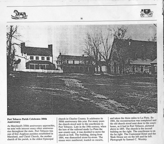
An 1895 photo shows Christ Church as it stood in Port Tobacco in the 19th century. This stone church replaced the 17th-century original, which had stood to the northwest across Port Tobacco Creek.
29 Friday Apr 2016
Posted in Edward Maddox, Maps
Dr. Edward Maddox owned numerous tracts in the Maryland Colony in the mid-1600s, mostly along tributaries of the Potomac River in Charles County and modern Prince George County. A recent survey conducted by the Broad Creek Historic District provides estimates of the locations of Edward’s Stone Hill, Lyon’s Hole and possible Athey’s Hopewell tracts. See the map below. The Vainall tract, which is used as a reference in some of Edward’s deeds, was centered on 38.756851, -76.985385.

Deeds/sources of Edward’s tracts:
Lyons Hole: Charles County Circuit Court Liber R, Page 144: 31 Dec 1690; Indenture from Daniell Smith of St. Mary’s County, carpenter, to Henry Goodridge; for 6,000# tobacco; a tract called Lyons Hole; bounded by Richard Fowkes’ Vaineall; containing 100 acres; formerly granted to Edward Maddocks by patent; /s/ Daniell Smith (mark); wit. John Wilder, Cleborne Lomax; ack. by Elizabeth Smith, wife of Daniel. [Note: Edward is untitled in this transaction (normally he’s called “apothecary”), and it’s possible that this Edward Maddocks is the younger Edward.]
Doges Neck: Charles County Circuit Court Liber H, Page 132: 5 Sep 1678; Indenture from Edward Maddock, apothecary, to John Reddick; for 30,000# tobacco; a parcel of land called Doges Neck; on the south side of the Piscataway River to the mouth of Chingamuxon Creek; laid out for 200 acres; /s/ Edward Maddock; wit. Rando. Brandt, Geo. Godfrey; acknowledged by Margery wife of Edward Maddock.
Cheshire: Charles County Circuit Court Liber I, Page 125: 5 Jun 1681; Indenture from Edward Maddock, apothecary, and Margery his wife, relict of Matthew Stone, to William Chandler, Gent.; a tract called Cheshires being part of Poynton Manor; inherited by Margery from the will of William Stone; containing 500 acres; for 40,000# of tobacco; /s/ Edward Maddock, Margery Maddock; wit. Tho. Hussy, John Richards.
Greene’s Purchase: Charles County 1671-1674, Vol. 60, Pg. 532-534: “Luke Greene acknowledged the ensueinge Conveyance unto Edward Maddock for two hundred acres of Land called Greenes Purchase in open Court Vizt…”
Stone Hill: Charles County Circuit Court Liber F, Page 22: 29 Oct 1674; Indenture from Henry Aspenall, planter, to Edward Maddocke, apothecary; for 20,000# of tobacco and 300 acres of Stone Hill; a tract called Doegs Neck on the south side of Piscataway River, bound by Chingamuxon Creek; laid out for 450 acres; also a parcel on the east side of the said neck by the sd creek containing 200 acres by patent granted Walter Hall 26 Apr 1658; Isl Henry Aspenall; wit. Richard Edelen, Stephen Murry
Athey’s Hopewell: Charles County Circuit Court Liber F, Page 180: 12 Apr 1676; Indenture from Edward Maddock, apothecary, to Philip Carey; for 3,000# tobacco; a parcel called Athey’s Hopewell; containing 100 acres; /s/ Ed. Maddock; wit. Philip Lines, Luke Greene
Maddock’s Folly: Charles County Circuit Court Liber F, Page 200: 8 Aug 1676; Indenture from Edward Maddock, apothecary, to Philip Lines; for 8,000# tobacco; a parcel called Maddock’s Folly; on the east side of Piscataway River; containing 350 acres; /s/ Edward Maddock; wit. Henry Bonner, Joshua Guibert, John Hamilton
Nanjemoy: Charles Co., MD, Land Record L #1, folio 142: 17 February 1684, Edward Maddock and wife Margery of Stafford Co., VA, conveyed 500 acres called “Nanjemoy” in Charles co. to Gerard Fowke.
16 Wednesday Mar 2016
In Charles County, Maryland, Cornelius Maddox owned a 60-acre tract called Tatshall in 1684-1688 (Charles County Circuit Court Liber L, Page 51, 26 Dec 1684). His presence there would have put him in frequent contact with Piscataway and Susquehannock Indians.
Early descriptions place Tatshall east of Portobacco Fresh (now called Port Tobacco Creek) and west of Zekiah Swamp (sometimes called Allens Fresh), “adjoining to the land called Moores Ditch [aka Moore’s Lodge] at the exterior bound thereof,” and abutting land owned by Hussey, Shaw, Lindsey and Smallwood. After a century of searches, the Moore’s Lodge site was found and excavated in 2008, revealing the locations of buildings owned by Maddox relatives Thomas Hussey and Samuel Luckett. On modern maps of the surrounding area, a stream called Maddox Branch, just south of the Moore’s Lodge site, flows west-east from 38.46744, -76.981926 to 38.475227, -76.957444, into Zekiah Swamp Run – and Tatshall probably lay along Maddox Branch. This means that Tatshall was almost certainly centered at about 38.481510, -76.968192. The tract was also called Tatall, Totsall, Tattsall, Tasch Hall and Nuthall in various records.
Zekiah Swamp was the location of a Piscataway Indian fort during Cornelius’ land ownership and until the Piscataways’ departure in 1692. The Indian fort, now called Zekiah Fort, was recently excavated by archeologists at approximately 38.569746, -76.872085 – about 8 miles northeast of Maddox Branch. Zekiah Fort was a last defense for the Piscataway, whose enemies the Susquahannock were seeking revenge for the Piscataway alliance with the British. The fort attracted frequent Indian skirmishes in the 1680s and 1690s.
Cornelius’ father-in-law James Smallwood served as an Indian agent, and had frequent contact with the Piscataway at Zekiah Fort. Cornelius’ neighbor and family business partner Thomas Hussey, who owned Moore’s Lodge, also had contact with the Piscataway, as evidenced by his September 1681 “statement that the raiding Indians had carried away eleven Piscataway (one man and ten women) from his plantation,” and that “Hussey had all of his linen, blankets, clothing, and rings stolen by a band of Indians.” (Md. Archives 17:20, cited in “A Place Now Known Unto Them:” The Search for Zekiah Fort)
04 Friday Mar 2016
Posted in Maps
Tags
benjamin maddox, charles county maryland, cornelius_maddox charles_county_maryland, edward_maddox cornelius_maddox
Numerous Maddox and Maddox-associated tracts are described in the Charles County Circuit Court Land Survey, Subdivision, and Condominium Plats, including a few we haven’t seen before.
The following tract was owned by Cornelius Maddox and we’ve never seen the original description:
Totsall, 60 Acres; Patent Record CB 3, p. 163; Date: 1682; Developer/Owner: Ashford, Michael. http://plato.mdarchives.state.md.us/msa/stagser/s1500/s1529/cfm/dsp_unit.cfm?county=ch&qualifier=S&series=1587&unit=4123
The first three of the following tracts were owned by Benjamin Maddox (I) and Benjamin Maddox (II), and the rest are associated with their sons:
Horne Faire, 150 Acres; Patent Record 17, p. 522; Date: 1674; Developer/Owner: Nevill, William. http://plato.mdarchives.state.md.us/msa/stagser/s1500/s1529/cfm/dsp_unit.cfm?county=ch&qualifier=S&series=1587&unit=2055
Horn Fair Addition, 30 Acres; Patent Record BC and GS 2, p. 182; Date: 1755; Developer/Owner: Maddox, Benjamin. http://plato.mdarchives.state.md.us/msa/stagser/s1500/s1529/cfm/dsp_unit.cfm?county=ch&qualifier=S&series=1587&unit=2058
Poseys Chance, 100 Acres; Patent Record LG B, p. 73; Date: 1739; Developer/Owner: Posey, John. http://plato.mdarchives.state.md.us/msa/stagser/s1500/s1529/cfm/dsp_unit.cfm?county=ch&qualifier=S&series=1587&unit=3260
Posey, 450 Acres; Patent Record AB and H, p. 170; Date: 1651; Developer/Owner: Posey, Francis Burlane, John. http://plato.mdarchives.state.md.us/msa/stagser/s1500/s1529/cfm/dsp_unit.cfm?county=ch&qualifier=S&series=1587&unit=3258
Batchelors Hope, 184 Acres; Patent Record C 3, p. 166; Date: 1695; Developer/Owner: Smallwood, James. http://plato.mdarchives.state.md.us/msa/stagser/s1500/s1529/cfm/dsp_unit.cfm?county=ch&qualifier=S&series=1587&unit=372
Blue Plains, 680 Acres; Patent Record BT and BY 3, p. 565; Date: 1747; Developer/Owner: Maddox, Edward. http://plato.mdarchives.state.md.us/msa/stagser/s1500/s1529/cfm/dsp_unit.cfm?county=ch&qualifier=S&series=1587&unit=497
Maddoxs Trouble, 236 Acres; Patent Record EI 2, p. 666; Date: 1738; Developer/Owner: Maddox or Maddux, John. http://plato.mdarchives.state.md.us/msa/stagser/s1500/s1529/cfm/dsp_unit.cfm?county=ch&qualifier=S&series=1587&unit=2540
The following tracts were wholly or partially owned by Edward Maddox:
Mannor of Poynton, 5000 Acres; Patent Record AB and H, p. 425; Date: 1658; Developer/Owner: Stone, William. http://plato.mdarchives.state.md.us/msa/stagser/s1500/s1529/cfm/dsp_unit.cfm?county=ch&qualifier=S&series=1587&unit=2582
Doags Neck, The, 450 Acres; Patent Record AB and H, p. 437; Date: 1658; Developer/Owner: Hall, Walter. http://plato.mdarchives.state.md.us/msa/stagser/s1500/s1529/cfm/dsp_unit.cfm?county=ch&qualifier=S&series=1587&unit=1170
Hopewell, 80 Acres; Patent; Patent Record CB 2, p. 44; Date: 1680; Developer/Owner: Athea, George. http://plato.mdarchives.state.md.us/msa/stagser/s1500/s1529/cfm/dsp_unit.cfm?county=ch&qualifier=S&series=1587&unit=2043
21 Sunday Feb 2016
Posted in Edward Maddox, Maps
When trying to understand early Stafford County, Virginia, land and parish records, it’s helpful to understand local parish name changes over time. Here’s a chronology:
Circa 1653-1680: Potomac Parish
Circa 1664-1680: Upper Parish (north) and Lower Parish (south)
Circa 1680-1702: Stafford Parish
1702-1776: St. Paul’s Parish (north)
1702-1785: Overwharton Parish (south)
1731: Hamilton Parish formed from land that transferred from Stafford Co to Prince William Co when Prince William Co formed
1776: Brunswick Parish formed in King George Co from Hanover Parish in 1732. A part was added to Stafford Co, when its boundary with King George was altered in 1776.
Dr. Edward Maddox bequeathed about 500 acres to his local Stafford Parish minister (Rev. Waugh) in 1694. This land was along the Passapatanzy Creek, just south of Marlborough Town. The acreage would form the Overwharton Parish glebe.
Source: http://vagenweb.org/parishes.htm
20 Thursday Aug 2015
Posted in Edward Maddox, Maps
Poring over documents related to Edward Maddox, presumed father of Cornelius Maddox, I stumbled upon a circa-1691 survey map of Marlborough Town, which lay on a spit of land surrounded by the Potomac River, Potomac Creek and Accokeek Creek in Stafford County, Virginia. It was intended by the aristocratic colonist William Fitzhugh to be a major port town for Virginia, but the local tobacco planters saw the plan as a British government effort to centralize trade and enforce taxation. Its original developers, including Doctor Edward Maddox and the rest of his fellow Stafford justices, managed to initiate the plans and start building on the site, but the initiative faded after just a few years.

“Doctor Maddox” can be read in plot #15 of Bland’s 1691 survey of Marlborough Town, on the right page.
“Doctor Maddox” is clearly written within the confines of plot #15 on the survey map, which was drawn up by Bland in 1691 and copied in a ledger by the Marlborough Town revivalist John Mercer in the 1730s. We already knew from John Mercer’s “Land Book” that Edward had owned the plot, and had sold it to his friend (and rabid anti-Papist) John Waugh after a short time. But I was surprised to see the doctor’s name written so clearly on such an old map – one of the earliest surviving surveys of the Virginia colony.
The Smithsonian archeologist C. Malcolm Watkins conducted a full survey of the Marlborough Town site in 1968 and published his results in The Cultural History of Marlborough, Virginia. He was able to definitively locate Edward’s plot #15, and it was easy to compare Watkins’ maps with Google Maps details. Doctor Maddox’s plot was located at 38.358003, -77.292369 (or 561-577 Marlborough Point Road). This was intended to be the center of town and his plot was surrounded by prominent Virginians’ plots.

An archeological survey of the Marlborough Town site reveals plot #15’s exact location, with modern-day Virginia Highway 621 underlaid.
